

ExtremeEarth will revolutionize Europe's capability to predict and monitor environmental extremes and their impacts on society enabled by the imaginative integration of edge and exascale computing and beyond, and the real-time exploitation of pervasive environmental data.
ExtremeEarth-PP is a preparatory project for ExtremeEarth, a proposed FET Flagship Programme FETFLAG-01-2018 of the European Commission (EC). It addresses the specific need, articulated in the Call for Preparatory Actions, for “New technologies and approaches for high-precision modelling and simulation, including the necessary data integration, that enable an in-depth understanding of the earth, natural hazards and climate change.”
Extreme natural phenomena – such as floods, droughts, wind storms, earthquakes, volcanoes, tsunamis – and the escalating impact of climate change – such as desertification, ice-sheet and glacier melting, sea-level rise – dramatically affect all sectors of society. Historically, environmental pressure on the human population has reshaped entire civilizations, and there is a need for effective mechanisms dealing with future change and extremes now.
Understanding and advancing our ability to predict the frequency of occurrence and intensity of extremes reliably is of paramount importance for efforts to make society more resilient to the environmental impacts of the present and changing climate, and it will allow European governments and businesses to plan more effectively than they are able for current and changing climate risks. Today’s lack of such ability originates from the inherent physical complexity of the Earth system, the chaotic nature of the underlying processes, the lack of sufficient and accurate observational data, the lack of accurate models to simulate the system’s complexity and uncertainty, and the missing link between physical science and impact models. ExtremeEarth will focus on applications with physical models encapsulating the complexity of the Earth system with unprecedented resolution and accuracy, and for which advances in computing can be expected to lead to a step-change in capability.
ExtremeEarth brings together Earth-system scientists and associated down-stream science and application communities, joining forces with those pushing the envelope in digital technology, to realize in the next ten years what seems unfeasible today. ExtremeEarth will greatly enhance our capacity to observe and monitor the state of the Earth, predict extremes, understand their underlying drivers, and predict their societal impact.
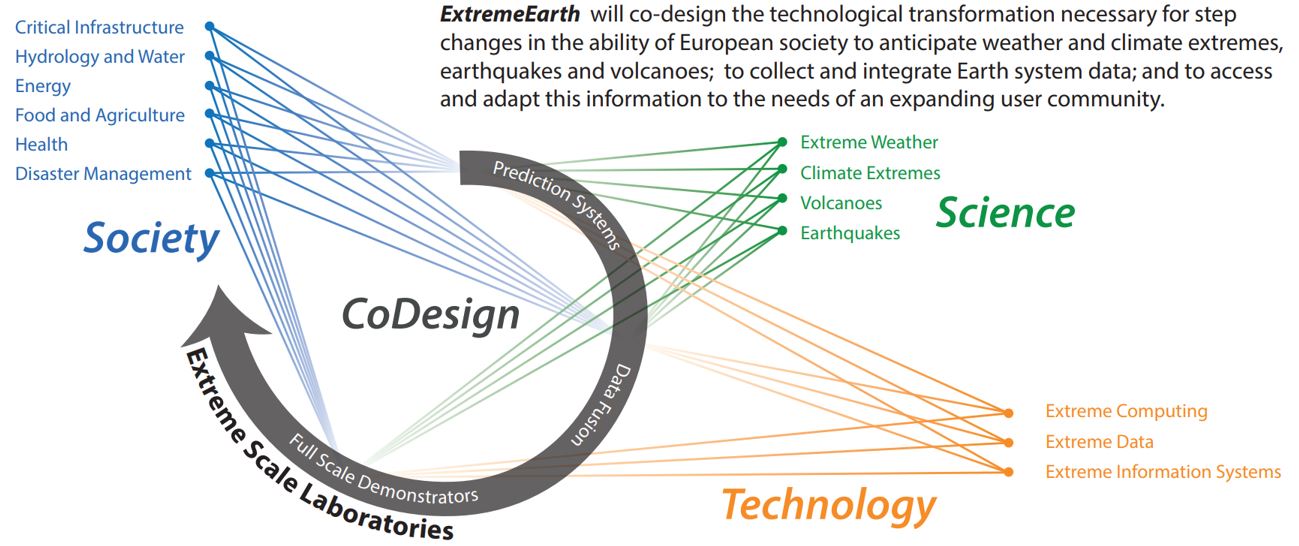
ExtremeEarth will strengthen Europe’s global lead in Earth-system prediction and produce a step-change in advancing societal resilience through the development of physical models to reliably predicting the occurrence of natural extremes, the assimilation of observational data across all scales and in real-time, the development of competitive digital technologies necessary to meet modeling, simulation and data challenges, and with Earth-system models driving the full range of impact models from hydrology to agronomy and energy supply, to economic, infrastructure and health risk management.
ExtremeEarth will develop the required Earth-system domain-specific processing capabilities at the interface between edge, cloud and centralized high-performance computing exploiting existing and emerging new data sources. ExtremeEarth’sdevelopment of ultra-high-resolution modeling capabilities of the entire Earth-system value chain will accelerate the development of exascale computing systems and data platforms in the coming years.
In concert with existing computing infrastructure programmes, suitable computer architectures will be employed to run Earth system models efficiently. ExtremeEarth will develop the software needed for these systems and work with commercial partners towards their exploitation in the broader market. ExtremeEarth will drive novel large-scale computing and data intensive methodologies across all disciplines for the first time, thus maximizing information extraction and minimizing cost. The goal is to create a unique production capability and to co-design the technological components required for its cost-effective operation.
The diversity and volume of Earth observation data requires the adoption of novel and efficient pre-processing and information extraction supported by edge-based computing infrastructures at the front-end, and user-friendly information analytics combining components of the Earth system at the back-end. ExtremeEarth will reform the handling and analytics of big data volumes along the science-to-impact modeling chain, and by including the vast resources of Earth observation data through complex data assimilation methods.
ExtremeEarth is an initiative of world leading Earth-system science centres in Europe supported by the European Network for Earth System modeling (ENES). ExtremeEarth involves the largest European high-performance computing and data handling facilities and it works in partnership with key European science and management consortia representing water, food, energy, health and insurance sectors to provide society with substantially improved estimates and impacts of extremes in a changing environment. By coordinating developments in concert with technology providers, existing services, monitoring networks and research infrastructures, including Europe’s Copernicus services and ESFRI infrastructures like the European Plate Observing System (EPOS), ExtremeEarth will produce a radical capability transition required for society to deal with environmental change and natural extremes.