

Science and technology breakthrough
ExtremeEarth will enable a break-through in our ability to simulate and predict weather and climate extremes, volcanoes and earthquakes, and in how users interact with this information. The break-through will be made manifest through science-technology solutions delivering levels of predictive accuracy with real value for a society grappling with their consequences. For the first time, reliable, impact-oriented forecasts will become available at scales that are relevant for decision-making in countries, regions, cities, coast-lines and large, medium, and small businesses. These predictions will be supported by a much-advanced capability to exploit observational information from existing and yet unused observatories and sensors.
ExtremeEarth strongly deviates from the traditional impact assessment approach, in which individual, disconnected communities operate downstream of the Earth-science modelling community, and use selected outputs as inputs to their own risk models. ExtremeEarth will implement a fully integrated science-impact value cycle allowing users to extract information from Earth system models and observations within time critical decision-making paths. Users will be able to interact at all stages with data and simulations on the desired level of complexity. These capabilities define the three ExtremeEarth Key Objectives.
These Key Objectives can only be realized by a substantial investment in technology that is co-developed with end users. Again, ExtremeEarth deviates from traditional thinking by focusing on geo-specific rather than general-purpose technologies. This is necessitated by computational requirements, as realizing the desired scientific advances is way beyond what will be achievable from a general-purpose approach. Here, software development is crucial. ExtremeEarth is proposing an investment into three Key Technologies: distributed extreme-scale computing, big data handling and an integrated information system. ExtremeEarth will hide the scientific and technological complexity (as much as possible) from the user, and still enable the user to employ the best science and impact models running on the best technological solutions.
Socio-economic benefits
While short-term forecasts of weather have improved significantly over recent decades, an ability to anticipate weather extremes on longer time-scales has not advanced apace, and predictions of volcanoes and earthquakes, or projections of climate extremes remain in a more primitive state. This contributes to European vulnerability and the high costs of natural disasters. First, many damages occur because current forecasting systems do not predict the precise location and actual impacts of extreme events with sufficient reliability and lead time to allow for proactive management. Second, poor models of long-term disaster risk result in damages that could have been avoided through targeted investments in safe buildings and infrastructure. The value of early and better information about the vulnerability of the built environment to present-day extremes and how these may change as a result of development trajectories on the one hand, or of a changing climate on the other hand. This will allow to optimize the long-term socio-economic trajectories and avoid the cost of inappropriate actions[1].
For example, all future protection strategies against earthquake and volcanic eruption impacts require a drastic improvement of our ability of predicting location, timing and extension of the next events. While the location of active volcanoes in Europe is known, the ability of anticipating specific extremes with improved precision and time will enable to calibrate mitigation measures such as evacuations, air-space protection and recovery. For earthquakes the overall knowledge is more scant as damaging earthquakes can take place anywhere in Europe, and catastrophic earthquakes can affect large parts of the Euro-Mediterranean region. Moving from the present-day assessment of hazard to time-dependent hazard will enable society to prioritize retrofitting measures and strengthening of all exposed infrastructures. The capacity of releasing accurate early warnings while the extreme event unfolds will drive rapid reaction and intervention measures. The detection of precursors or the preparation phase of an impending major earthquake would then open opportunities for a different strategy of rapid intervention.
When planning for the coming decades, governments and private sector companies need detailed projections on (i) the expected socio-economic impacts of extremes; (ii) adaptation measures to reduce damage, and (iii) their cost. Cutting-edge modelling capabilities for both solid and fluid Earth developed in ExtremeEarth will provide this information at the required resolution and accuracy, enabling substantial progress in enhancing the resilience of European society and its investments.
ExtremeEarth will contribute to both short-term preparedness as well as long-term resilience building. For short-term warnings, ExtremeEarth will enable forecasts of the socio-economic impact of extremes (for instance real-time shake maps from earthquakes, or flood scenarios) with sufficient location and information detail, so that crisis managers can tailor their preparations to manage evacuations, protect critical infrastructure, deliver medical support, water and relief to the areas that need it most, especially to prepare before the disaster happens. Current early warnings have reduced the number of casualties by thousands around the globe and the economic benefits of early warning systems run into many billion €[2] – with potential for improvement again in the billion €.
With sufficient lead-time, vulnerable people can be evacuated and assets can be moved while stockpiles of relief supplies can be assembled already in advance of the event, further reducing the number of casualties and the recovery time after the actual event and increasing the resilience. This contributes to the Priorities for Action of the Sendai Framework for Disaster Risk Reduction[3], its proposed implementation in the Global Risk Assessment Framework (GRAF) and the European Commission action plan[4] - including the priorities on understanding all dimensions of risk, strengthening disaster risk governance, investing in disaster risk reduction for resilience, and enhancing disaster preparedness for effective response. ExtremeEarth will provide timely and accurate Earth-system information that is prerequisite to the proposed pan-European disaster risk prevention framework and response mechanisms to be developed under the ambitious European Scale rescEU framework[5].
In addition, the Earth-system technology concepts of ExtremeEarth will allow for a comprehensive assessment of the benefits of proposed measures to adapt to climate change or manage development. With such information, ExtremeEarth will strengthen the EU leadership in a highly connected, global community to evolve towards a sustainable and resilient global economy by providing the capabilities for a more science-based planning. Among other things, such actions will, for instance, allow ExtremeEarth to help its partners contribute to initiatives such as the five-year global stocktaking assessment of the Paris climate agreement to provide contributions to the Intergovernmental Panel on Climate Change (IPCC), and contribute to good practice on greenhouse gas and climate impact reporting under the United Nations Framework Convention on Climate Change (UNFCCC).
ExtremeEarth-PP will allow assessing the quantitative socio-economic impact potential together with relevant stakeholders in a dedicated work package (WP4-5) to provide estimates of the return on investments. The preparatory project engages stakeholders from industry, government, and civil society to design how these groups will collaborate with modellers during the ExtremeEarth project, ensuring that users will co-design tools for accessing and visualizing Earth-system information.
Industrial support and European competitiveness
The race for leadership in HPC systems is driven both by the need to address societal and scientific grand challenges more effectively, such as preventing large-scale catastrophes, and by the needs of industry to innovate products and services. The industrial landscape continues to undergo dramatic changes following the digital revolution including the adaptation to robotics, AI, and big-data analytics techniques.
ExtremeEarth will be both a beneficiary of the changing digital environment and a contributor to on-going change. ExtremeEarth’s initial industrial impact provides a boost to a relatively small, but quintessential European HPC industry. To this end, ExtremeEarth will provide a competitive advantage for the market of HPC systems specifically developed for environmental forecasting centres, including the combination of HPC, modern sensor technology, new visualisation technology and big data. Beyond HPC, the full integration of computing, data and cloud technologies is already on the horizon, but ExtremeEarth is much larger in scale, and it takes a crucial application perspective not seen by current major commercial cloud providers. This will result in a major competitive advantage to applying generic technology in other sectors. It will further boost a growing market of larger technologically advanced industries working in applications of high definition forecasts, e.g. in the food and energy sectors (e.g. Bayer Crop science and Arcadis)19. EEsC will give the technologically advanced industries much greater access to accurate assessments of natural hazards and their impacts, and serve as a platform for innovation more broadly.
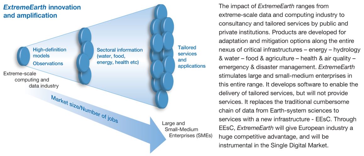
Many of the benefits from ExtremeEarth will be felt by changes to the services delivered by its partners. Researchers currently target their scientific expertise to inform the society as to potential hazards, e.g., from climate change or volcanoes. The capabilities ExtremeEarth will develop will move away from more assessment-focused research outputs towards research that allows the fruits of this research to be easily transformed into actual services. The co-design process ensures that this capacity will be developed in collaboration with scientists, applied research institutes, Small and Medium-Sized Enterprises (SME) and engineering companies alike, who can each test their innovations on the platforms that ExtremeEarth will develop.
ExtremeEarth is a game-changer that will enhance the competitiveness of all European agencies and agents involved in, or touched by, environmental extremes, to combine exposure and vulnerability information with weather, climate and geo-hazard information, identifying hotspots of risk that require pro-active investment. We are only beginning to comprehend the opportunities afforded by this investment, but ExtremeEarth-PP will specifically flesh out scenarios and trajectories in this impact area by reducing risk, developing industry and sparking off new applications and services.
[1] https://www.ncbi.nlm.nih.gov/pubmed/26438286
[2] http://www.unisdr.org/files/3612_GlobalSurveyofEarlyWarningSystems.pdf
[3] http://www.unisdr.org/files/43291_sendaiframeworkfordrren.pdf
[4] https://ec.europa.eu/echo/news/european-commission-launches-sendai-action-plan-disaster-risk-reduction_en
[5] https://ec.europa.eu/echo/news/resceu_en